
What are the requirements for a rapidly expanding city to accommodate young new residents? Can new towns contribute identity, not just amenity?
From 2006 to 2007, the NOW Institute advised the city of Madrid on the future of Spain's new town model. Madrid Now examined how generic new town planning could better support identity, diversity, and stronger urban character.
The study focused on Madrid's PAU (Programa de Actuación Urbanística), a housing program created to provide affordable, high-quality housing for a growing population of young residents. Homes were assigned through a lottery system, offering limited choice and often requiring long wait times.
The research identified several challenges within the PAU model. Rigid parcel planning limited flexibility and made it difficult to integrate future civic, cultural, and commercial uses. Low-density development encouraged outward expansion and reduced the potential for more efficient urban growth. Standardized planning also overlooked local context, limiting each district's identity and connection to Madrid's urban culture.
In response, the city identified three sites for design exploration. Each addressed a distinct urban challenge: one reimagined transportation efficiency, one proposed an off-grid urban farming community, and one explored a new model for high-density residential living.
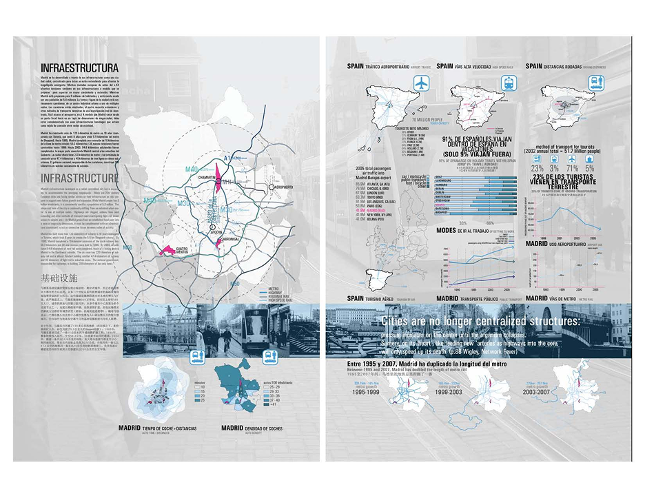
Madrid's infrastructure grew from a centralized, radial city model, but its expansion now reflects the scale of an emerging megacity. Like many older European capitals, Madrid faces growing pressure to adapt historic systems for future growth. While the city proper has 3 million residents, it serves nearly 5.8 million people across the wider metropolitan region.
As Madrid shifts from a single urban center to a network of multiple nodes, many satellite communities still depend on the historic core—placing increasing strain on existing infrastructure. Highways are congested, transit lines require expansion, and stronger connections between urban centers are needed to support continued growth.
To address this, Madrid has made major investments in public infrastructure. Over the past decade, the city built more than 120 kilometers of new subway lines, alongside expanded light rail and bus networks. By the early 2000s, these transit extensions had significantly improved connections between central Madrid and its growing suburbs.
The city also expanded regional mobility beyond rail. Dedicated bus corridors were introduced to improve highway transit, and the new Madrid-Barajas International Airport, opened in 2006, added another major transportation link to the region. Together, these systems began to establish the infrastructure needed to connect Madrid's growing urban network.
Madrid has long relied on engineered water systems to support growth in a dry climate. For centuries, its water supply came from underground channels fed by rainfall and snowmelt from the Guadarrama Mountains. These early systems served the city until the mid-19th century, when rapid population growth led to the creation of Canal de Isabel II in 1858, diverting water from the Lozoya River and establishing the foundation of Madrid's modern water network.
Today, Madrid's water system is managed not by the city, but by Canal de Isabel II, a public utility operated by the regional government. It oversees drinking water, wastewater, and the full water cycle across 161 municipalities, serving more than 5.2 million residents across the Madrid region.
Madrid's water infrastructure is shaped by its geography. The region sits within the Tagus River basin and depends on a wider network of rivers, reservoirs, and mountain-fed tributaries. While much of the metropolitan area lies on a dry central plateau, the Sierra de Madrid provides critical water resources through seasonal rainfall and snowmelt.
This geography creates a clear regional water cycle: water is collected in the northern mountain watersheds, distributed across Madrid and its metropolitan area, and discharged through the lower river systems to the south. As the city expanded, this network evolved into a highly regulated system of reservoirs, aqueducts, treatment plants, and distribution infrastructure.
Madrid's climate makes this system especially important. With hot, dry summers, limited rainfall, and nearly 300 days of sun each year, water has long been one of the city's most critical infrastructural systems.
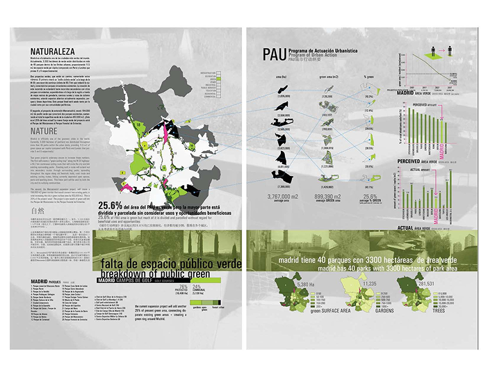
Madrid has one of the most extensive urban park systems in Europe and is now recognized as one of the world's greenest cities. Over the past decade, major public investment in trees, gardens, and open space has expanded the city's green infrastructure across more than 40 parks within the urban core.
Today, Madrid includes roughly 3,300 hectares of parkland, providing 11.5 square meters of green space per resident—more than cities like Paris and London. From historic landscapes like Casa de Campo and El Retiro to newer green zones across the metropolitan edge, the city's park system has become a defining part of its urban identity.
Madrid continues to expand this network through large-scale green infrastructure projects. One major initiative is a 60.7-kilometer green cycling loop along the M-30, designed to connect existing parks, open spaces, and recreational corridors across the city and surrounding region. Extending through former rural paths and secondary routes, the loop links previously disconnected landscapes into a continuous public network.
A second major project, the Mercamadrid expansion, introduces a 194,000-square-meter green corridor connecting Parque del Manzanares and Parque Forestal de Entrevías. Together with related improvements, the project adds more than 450,000 square meters of new green space while also supporting logistics, business growth, and employment. In Madrid, green infrastructure is being developed not only as public space, but as a long-term urban and economic asset.
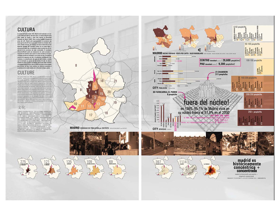
Madrid, the capital of Spain since 1562, sits at the center of the Iberian Peninsula and functions both as a national capital and as its own autonomous region, the Autonomous Community of Madrid.
Historically, Madrid's growth was concentric, expanding outward from its historic core. Like many pre-20th-century European cities, this pattern has shifted since the mid-20th century. Today, growth is multi-nodal: new urban areas emerge across the periphery with their own centers of activity, rather than depending solely on the historic city center.
This transformation is driven by several forces: rural-to-urban migration, rising life expectancy and population growth, international immigration, and the reclassification of rural land into urban development zones. As a result, the "radius of life" continues to expand beyond traditional city boundaries, placing pressure on planning systems and institutions to manage more dispersed urban conditions.
This shift also raises broader environmental concerns. Although cities occupy only a small fraction of the Earth's surface, they concentrate a disproportionate share of global impact—housing nearly half the population while consuming most resources and generating the majority of emissions and waste.
Madrid's public housing authority, EMVS, has developed an urban housing program called PAU (Programa de Actuación Urbanística) to expand access to affordable, high-quality housing and improve social equity.
Over the past decade, much of Madrid's growth has occurred on the urban periphery. Within this development, only a small share of new housing is publicly managed, while the majority is privately developed. EMVS projects aim to ensure that publicly built housing contributes to a more balanced city—preventing displacement, supporting stable communities, and improving overall urban quality.
The program is guided by broader social goals: improving living conditions, integrating housing with access to education, healthcare, culture, and leisure, and encouraging civic participation through neighborhood associations and greater access to decision-making processes.
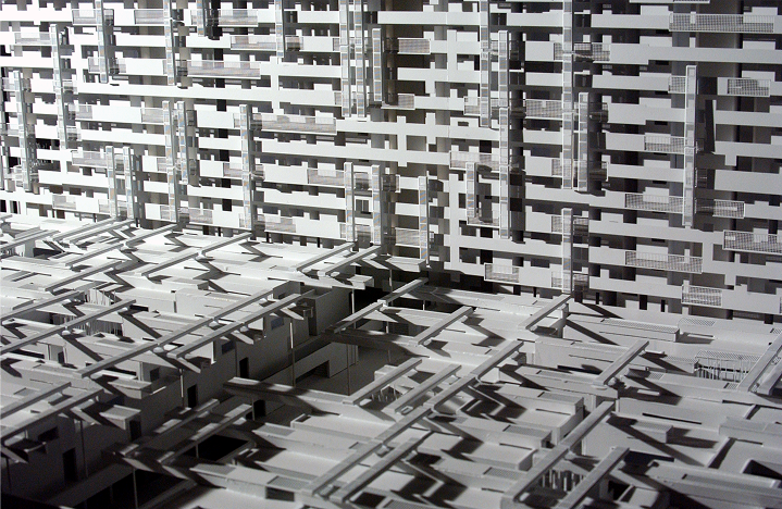
One of EMVS's strengths is its engagement with architecture as a civic tool. The agency has commissioned both international and Spanish practices—including firms such as MVRDV, David Chipperfield, Toyo Ito, and others—to design housing projects. This approach has helped reduce the stigma often associated with social or low-cost housing by bringing high design quality into public development.
However, challenges remain. Environmental integration within these projects is still limited, and community participation tends to diminish after initial planning phases. Earlier planning processes also produced high-density developments that prioritized land availability over long-term livability.
Overall, the PAU system has enabled large-scale housing delivery, but it often results in isolated, self-contained districts with separate zones for housing, commerce, and transport. While it successfully provides homes for many residents, there is significant opportunity to improve integration, sustainability, and long-term urban cohesion.
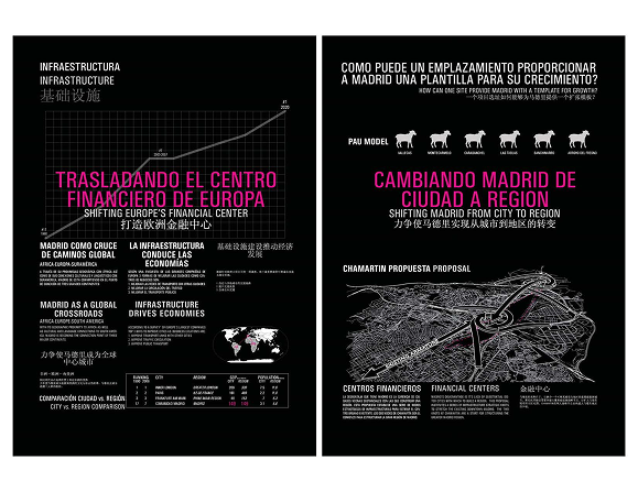
The site is located in northern Madrid and is defined by Chamartín railway station, the city's second-largest rail hub. It serves regional, national, and international routes toward Barcelona, Bilbao, San Sebastián, Paris, and Burgos.
A major planning proposal, known as the "Chamartín Operation," envisions submerging and reconfiguring the existing station infrastructure to free up surface land for large-scale urban development. The project extends Madrid's central north–south axis, Paseo de la Castellana, further north into Chamartín, effectively expanding the city's financial core.
The broader ambition is to transform the area into a new economic district, reinforcing Madrid's role as a financial center in Southern Europe and attracting international investment through large-scale mixed-use development.
The second site is located at the Abroñigal Cargo Terminal in southeastern Madrid, positioned between the M-30 and M-40 ring roads along the RENFE corridor. The site spans 204 hectares, including a 70-hectare freight facility capable of storing up to 3,000 TEUs (approximately 1,500 standard 40-foot containers). It currently handles around 15 incoming and 15 outgoing trains per day.
Established in 1974 as a logistics and cargo depot, Abroñigal is now the focus of a major transformation strategy. Plans propose relocating and upgrading rail infrastructure to create a new high-speed rail hub integrated into the city's passenger network, shifting part of Madrid's rail operations toward the southeast.
The redevelopment would reprogram the site from a freight-only terminal into a major passenger gateway, connected to Spain's high-speed AVE network. It is also linked to a broader proposal to redistribute rail traffic between Madrid's main stations, reducing pressure on central infrastructure and improving north–south mobility through a new underground connection between Atocha and Chamartín.
The Atocha–Chamartín tunnel would enable a 10-minute transfer between stations, increase rail capacity, and significantly improve system efficiency. It also supports expanded parking and multimodal infrastructure, increasing both train capacity and supporting services.
While the project is designed to reactivate one of Madrid's least economically active zones and create a new southeastern "gateway" to the city, it remains controversial. Local communities and city officials have raised concerns about relocating major transport functions away from the historic center, citing risks to urban balance and accessibility. The total investment is estimated at approximately €900 million.
The third site is located at Madrid–Cuatro Vientos Airport, the oldest airport in Spain, established in 1911. Positioned approximately 8 km southwest of central Madrid, it operates today as a joint civil–military aerodrome supporting general aviation.
The airport includes a 1,500-meter paved runway (10–28 orientation) and an additional unpaved runway used exclusively for military operations. Despite its limited size, the site records significant aviation activity, with tens of thousands of annual flight operations and continued use for both civil and cargo functions.
Although usage remains active, the site is being reconsidered as a potential zone for urban redevelopment. Its location within the metropolitan boundary and its largely flat topography make it a strong candidate for future residential expansion.
The nearby transit connection, Puerta del Sur Metro Station (translated as "Gate to the South"), reinforces its role as a key southern access point to the city. As one of the last large undeveloped areas within Madrid's limits, Cuatro Vientos represents a strategic opportunity to extend the urban fabric and serve surrounding districts through future growth.